When we talk about a livable city, when we talk about how we want Limerick to be in twenty years time, there is broad agreement that we want to make the city centre a more pleasant place to live. Limerick city centre does not currently make the most of two important aspects of the city. One, of course, is the river, but another, not so often discussed, is the Special Areas of Conservation that lie in close proximity to the city centre. These nature reserves at Westfields and Corbally are areas of tranquility very close to the city centre. Along with the Park Canal walk out to the University of Limerick, these areas have the potential to transform how we see the city.
Limerick city is lucky to have Special Areas of Conservation close to our city centre. We have a city criss-crossed with wildlife reserves and parkland. The council has recently focused on upgrading the cycle and footpaths through Westfields and along the Park canal and out to the University of Limerick. Both projects have been a considerable success and the Council should be commended for the work that has been accomplished to date. Ideally a similar focus could be turned towards providing similar amenities around King’s Island and Corbally. In Limerick we should always consider that we live at the edge of the Shannon estuary and our city is surrounded by areas of tremendous natural beauty.
There is another reason to upgrade these facilities. In 2014 the flood protections around King’s Island failed and caused significant flooding on the Island field. While the council are currently completing repair work by Verdant Crescent, it is clear that at some point in the near future more extensive repair work will be required to the various floodwalls not just around King’s Island, but also around Corbally. Ideally these flood protections would also have the benefit of improving the current pathways around the city’s rivers. Is it possible to increase the city’s flood protections while simultaneously increasing the amenities available to the city? As a result of recent flooding along the entire Shannon, the city needs to make sure it is prepared for any future floods.
We should not see the 2014 flood in isolation. The Shannon river has always flooded. Its origin myth expressly warns us that it is a river prone to flooding*. In recent years flooding has been a growing issue all along the Shannon, partly due to climate change and partly due to unsuitable building in areas that were traditionally reserved as floodplains for the river.
Repairing the flood defences is obviously a costly exercise and one that requires significant planning. One factor that should be considered when the flood protections are repaired is to extend beyond the current flood walls but rather turn them into amenities in their own right. Every flood wall could incorporate a cycle-track and a footpath to increase and promote the number of river walks in the city. These paths would open these areas while also serving to protect them from future flooding.
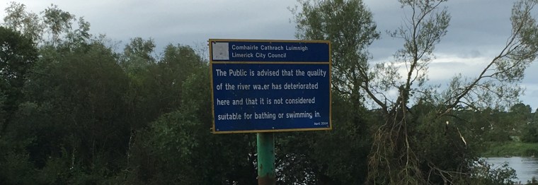
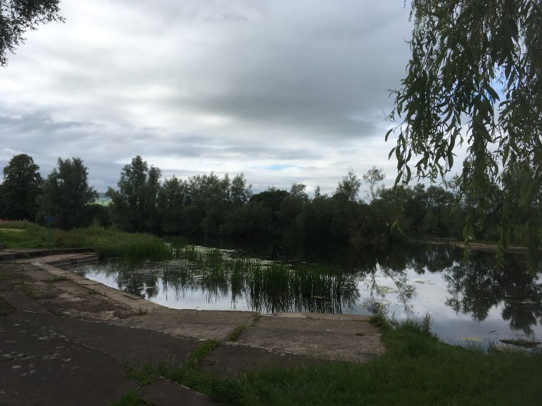
To take the example of the Salmon-wier/Sandy path in Corbally. The Salmon-weir/Sandy path along the Abbey river and onto the Shannon river is an incredible amenity to have so close to the city. This path runs from O’Dwyer bridge around the Lax weir. On one side of the path is a river while on the other is a large nature reserve. It is a shame to see it atrophy to the point where it is only usable when walked in single file and wholly unsuitable for cyclists or people with buggys. It is so hidden away that many people in the city seem to forget about its presence. While this adds a sense of tranquility to the path, it also means that many, perhaps even most, of the people of Limerick can’t enjoy it.


The path itself is a state of poor repair, with its surface too uneven to be a pleasant cycle. When the flood wall is repaired, the repairs should allow the path to be accessible for all users, and ideally would allow for access to the river to boats, fishermen, swimmers and kayakers. Currently bright blue kingfishers are nesting near the red path in Corbally, the area is a vital wildlife reserve and bird sanctuary and any development should be sensitive to the wildlife living there. It shouldn’t be an either/or debate between those who wish to preserve it and those who wish to utilise it.
An unusual feature of the Salmonwier path is that all the public seats face away from the river, which is understandable when you consider that across from the path was formerly the city dump at Longpavement. The dump closed in 2002 but long awaited plans for its redevelopment stalled during the financial crisis. In that respect it’s not surprising the path has been neglected, its proximity to the city dump would have impeded its popularity.


We should be seeking to develop a walking and cycle trail the allows everyone in the city appreciate how fortunate the city is to have wildlife reserves so close to the city centre. This path, which joins the red path at the Lax weir (a 12th century weir across the Shannon mentioned in Charters that pre-date the Magna Carta) has the potential to be a significant amenity for the city, and would complement the Westfields and UL paths. As mentioned, Limerick city centre is nestled in amongst areas of natural beauty, it should be open to all to appreciate it.
Over the last decade, the Council have made a serious and determined effort to rebuild and repair the river paths through Westfields park, along the boardwalks and most recently, out the Park Canal and along the river to the University of Limerick. Each of these projects allow users enjoy pleasant walks through nature reserves and along the river. It is easy to envisage a time when the path around Corbally and King’s Island is accessible to everyone, and for the benefit of everyone.


*Two separate origin myths allude to flooding.
“Legend has it that Síonnan, ,the daughter of Lodan (a son of the Celtic God of the Sea, Lír), came to the Shannon Pot in search of the great Salmon of Wisdom. The great salmon was angered at the sight of Síonnan and caused the pool to overflow and drown the maiden. Thus the Shannon was created and still bears her name today.”
and another
“According to the Dinnsenchas, Luimnech is so named from a contest which took place there between two swineherd champions, who were brothers named Rind and Foebur, sons of Smucall, in the employment of Bodb of Sid Femin, the fairy King of Munster, and Ocaill of Sid Cruschan, the fairy King of Connacht. The assembly which has come from the south and north were so engaged in admiring the feats of the champions, that the tide carried off their shields which they had left on the strand. So looking from Tul Tuinne,a hill beside Lough Derg, they exclaimed, “is luimnechda in t-inbuir?” – “the inver is full of shields”. So the inver was named Luimneach.” (Inver in an anglicisation of the Irish for estuary).